Wednesday, December 2, 2015

3.1.3 - The Hydrosphere (KQ1): Human-Caused Flooding

3.1.3 - Human-Caused Flooding

Floods from rivers can be devastating. They can destroy homes, wash away buildings, ruin land, and cause death.  Often, river flooding is unavoidable and part of a natural recycling effort of the earth, and humans tend to avoid areas prone to flooding...but there are human actions that can cause an area around a river that is normally not to become prone to flooding.  The main anthropogenic (human) causes of river flooding are urban development, deforestation and agriculture.

Urban Development - If a place along a river is developed, the land is cleared and buildings, roads, and other structures are constructed.  When water builds in heavy rains, instead of percolating into the ground, it will run off the concrete/asphalt into the lowest elevation...the river.  This, in turn, will cause the river water levels to rise and then flood the developed area from which it originally flowed.  Place can combat river flooding by installing dams (floods the area behind the dam instead), installing levees (walls to protect the urbanized land), and divert the natural flow of water away.  Of course, all of these disrupt some other area and ecosystem.  

Deforestation - Because roots provide structure needed to hold soil, they in turn are needed to hold water,.  Without a strong soil/hummus layer, there is no way a forest can have water percolation.  Thus, in essence, this acts just like urban development...if an area is clear-cut or deforested, the water will run to the lowest part, the river, and can cause flooding of the area, thus destroying even more of the ecosystem.  Watch this video of the devastating impacts of deforestation of flooding in Haiti.

Agriculture -  In much the same way as the other two causes, changing a land from what it naturally is to farm land disrupts the natural water flow, and can again cause river flooding.  The flooding can then, in turn, ruin the crops on the farm land.  To combat this, farms may build water storage systems in case of flooding, build water diversions, or build their own levees around the farm to prevent flooding.

More - There is some good information and specific case studies on this site that will help you further understand the human causes of river flooding.  Please read over the entire site (all 6 parts) and the case studies associated with it, as they give you a really great understanding of not only the causes, but management solutions you will need to know and recall.

Your turn to put your knowledge into action! Play the following simulation game for the flooding scenario. If you can win the game (not fail), show me a screenshot of your score for 5 bonus points on the next exam!

Tuesday, December 1, 2015

3.1.2 - The Hydrosphere (KQ1): The Effects of Human Use on the Supply of Water


The Effects of Human Use on the Supply of Water

The effects of agriculture, industry and domestic usage upon natural supplies of water will be studied in this section.  As you are probably aware, all of these facets of human life use water, and thus have a profound effect on our natural supply of it.

Agriculture - We learned a little about agricultural water use in our soil unit.  Click this link by the USGS to read about water use in agriculture, specifically in terms of irrigation.  It starts with general irrigation terms and techniques and then gives some specifics on the US.  Also, read here for the different types of irrigation used in agriculture. Click on the links within both if you do not understand the terms or want to see specific examples.  As our biggest (by far) user of freshwater, efforts need to be made to reduce the amount needed for crop production and animal husbandry.  Overuse of freshwater in agriculture can lead to desertification, salinisation, contamination, and drought.

Industry - Industrial water use is something that is often overlooked.  In fact, almost all industrial processes use fresh water.  Read this link from the USGS to learn more about industrial water use.

Domestic - While it pales in comparison to the overall use of water by the other two sectors, domestic (home) water use is what we most directly rely on.  This link takes you to a good overview with important graphics on domestic water use.

Monday, November 30, 2015

3.1.1 - The Hydrosphere (KQ1): The Main Storage Zones of Water

The Main Storage Zones of Water

Watch this video from NASA as a introduction on how water is distributed globally.


So, where is our water?  We know that 97% is salt water that we cannot use, so where is the rest???  This graphic breaks it down well:


As you can see, of the 2.5% that is fresh, 68.6% of it is unusable in glaciers and ice caps.  30.1% we can get, but have to pump out of, the ground. Less than 1% of our total FRESHWATER is easily retrieved from lakes and rivers.  This makes it extremely important to understand that while it looks like it from space, our water supply for human use is not limitless.

Water Cycles

Global Hydrological (Water) Cycle

The global water cycle is probably the one you first heard about in elementary school.  It is a closed system, in that the is a full cycle.  Water stays in, on, or above the earth.  It does not escape and, thus, we never "lose" or "gain" water.  Is goes in and out of different phases, but it is always water.  This graphic shows the global water cycle well.


Let's go over some of the processes described above:

Evaporation- When standing water is heated by the sun (or any other process), the water molecules will begin to move rapidly and some will break the barrier between the water and the air and enter the atmosphere.  This is the primary process by which water enters the atmosphere.

Precipitation-  Water in the atmosphere will eventually cool.  It can then form liquid droplets in the form of clouds.  When there is enough condensation, the droplets will fall to the surface of the Earth.

Interception-  This term is not in the above graphic, but interception is when precipitated water does not reach the soil below.  This primarily happens with tree leaves and leaf littler.  It can reduce the recharge of aquifers of surface waters.

Runoff-  When precipitation falls and hits ground, it will "run off" to the lowest elevation.  If enough collects, the runoff can form a river and will eventually end in a lake or larger water body (ocean, gulf, sea).  Snow melt will also provide runoff.

Infiltration-  Any water that is absorbed by the soil will then "infiltrate" or percolate until it collects below the surface.  The rate of infiltration is very important to both how quickly groundwater or an aquifer is able to be recharged (quicker rate = faster recharge) AND how well soil is able to absorb water (lower rate = more absorption), which is important for agriculture.

Groundwater-  Water that is infiltrated is stored underneath the ground in the aquifer.  This is known as groundwater.  In Florida, we get our drinking water from an aquifer.  In other places, where an aquifer is not available, people get their water from SURFACE water (lakes, rivers, streams, etc.).

The groundwater is recharged over time.  If the rate of water leaving the aquifer (via wells being over-pumped for agriculture, drinking, etc.) is greater than the rate of recharge, the aquifer level will drop and may become inaccessible.  The water table, shown below, is the point at which the ground is saturated (full to the max) with water.  If the water table is higher than sea level, the freshwater will stay; however, if the aquifer is overdrawn, the water table will drop, and if it becomes lower than sea level, saltwater will infiltrate the groundwater, making it unusable.  This is called saltwater intrusion.

Also shown in the graphic below are three different types of aquifers that can be used to draw out freshwater.  They are:


  • Confined-  Confined aquifers sit below a impermeable rock/hard clay layer...water cannot escape.  They are recharged from a distance.  They are usually under immense pressure because of the rock layer, and therefore, if tapped with a well, can produce what's known as an Artesian well.  Basically, an Artesian well is a well that does not need a pump...it flows above the water table on its own.  They are usually not very susceptible to pollution because of how far away the recharge areas are.
  • Unconfined-  Unconfined aquifers are close to the surface and are recharged locally by infiltration.  They may have an impermeable layer below the aquifer.  There's usually not a lot of pressure, since there is no hard layer holding the water in, so when they are tapped for wells, they must use pumping systems.  They are more susceptible to pollution due to their proximity to the surface.
  • Perched-  A perched aquifer is a type of unconfined aquifer that sits above another unconfined aquifer because water infiltrating from the surface is trapped or 'perched' on a shallow impermeable layer.  Perched aquifers are important because they are so close to the surface (easy to get to) and they can be the source of natural springs.


Local Hydrological Cycle

While the global hydrological cycle is closed, the local systems (for example Florida) are open.  Water gets stored in the ground or on the surface, may increase or decrease the amounts, can move to other regions, etc.  This is all based on the climate conditions and how humans use the land.  Please read about Florida's water cycle here.

Saturday, October 10, 2015

2.4.4 - The Lithosphere (KQ4): Soil MEDC and LEDC Case Studies

Soil MEDC and LEDC Case Studies

As with almost any environmental topic, the differences in how soil issues are handled in terms of preparation and response in MEDCs and LEDCs are quite different.  Here, you will read about one of each.  Pay close attention to the differences in how the respective governments handled them.  Yes, one is the US during the Depression...and yes, it was bad; but, the county did recover and prosper where as a LEDC may not.


MEDC:  The USA Dustbowl (Will open as a PDF)...Peer Reviewed article!!!

Quick questions...what did the USA learn from this experience?  How have things changed?

LEDC:  African Soil Degradation (Click on the article link within to get more detailed info)

REMIND HARSHMAN TO DISCUSS NUTRIENT CYCLES TOMORROW

2.4.3 - The Lithosphere (KQ4): Soil Management & Specific Profiles

Soil Management

Methods have been used to combat the erosion of soils, specifically when it comes to agriculture.  We have learned a lot from past events, and employ some very good, ecological techniques.  You will read about some of the past issues in the next blog, but here we will discuss the techniques to prevent them from happening.  These managements strategies are put in place to sustain and restore fertility and increase economic benefits and crop yield.

Cover Crops

Cover crops are crops that are planted alongside the target crop to increase soil quality and fertility and decrease soil eroision along with other benefiting factors such as pest and disease control.  A cover crop will be planted in a field with the target crop, and may be plowed underneath the ground to provide nutrients to the crops surrounding it.  Often times the cover crops are legumes (beans/peas), as these types of plants take nitrogen from the air, and "fix" it into a form that plants can use.  Here is a picture of cover crops placed alongside the target crop.
Image result for cover crops

Cover crops also improve the amount of organic matter in the soil, by replacing what would just be empty space of dirt with vegetation that contributes to the nutrients of the soil.  They decrease soil erosion and improve water retention of the soil by covering up exposed soil (less soil leaves in runoff) and thus providing a way for water to trickle down through the soil.


Crop Rotation

Crop rotation is the practice of planting different crops during consecutive growing seasons.  By doing this the following benefits are applied to the soil and plants:

  • The nutrients used by one set of crops may be different than those utilized by another.  By rotating crops that differ in their nutrient requirements, the soil will be less likely to be diminished of these nutrients upon harvesting.  If cover crops are planted every other season, then the nitrogen content can be increase for the target crops.
  • Different crops have different root lengths, so rotating crops can have the effect of the crops taking nutrients and water from different levels over the seasons, resulting in a lower need for fertilizers and irrigation.
  • Pests and disease tend to foster if one crop is left in an area for too long.  By rotating crops, farmers can limit the amount of these and, thus, increase yield and decrease the amount of pesticide used.


Nutrient Management

Nutrient management is the practice of not "over fertilizing" plants.  The farmer studies the amount of nutrient his/her crops needs and tests the soil to determine the amount of fertilizer to spread.  Too much fertilizer can result in run-off of the fertilizer, which can have a negative effect on surrounding water bodies.  Not enough nutrient will cause the crops to not grow, loose soils, and erosion.  By practicing nutrient management, farmers can optimize their crop management.

Tillage Management

Tillage is the agitation of soil after harvesting.  It basically breaks up the soil and aerates it, which has been used to "prepare" it for the next growing season.  While it does provide aeration and preparation of the soil, tillage also leaves soil open to erosion, can destroy the organic layer of the soil, and destroys the water capacity of the soil.  No-till methods aerate the soil without tillage, and methods that decrease the amount of tillage are recommended for soil health.

Water Management

We will talk more about this in the hydrosphere unit, but it is obvious that over-watering a crop area will result in erosion of soil.  Over-watering is done at many crops areas and results in flooded fields and eroded soils.  To counteract this farmers can plant crops native to the area that do not require external irrigation or employ minimal water techniques, such as drip-irrigation - the process of only watering  the crops themselves by using a hose with small holes at each crop.  Here is an graphic of a drip irrigation system:

Shelter Belts

Shelter belts are lines of trees planted around crop areas to cut wind erosion.  The trees block the wind and reduce the amount of soil that is eroded.

Contour Farming

Crops are planted on the contour (slope) of the land as to follow the water flow pattern.  This minimizes flooding of the crop area, and regulates the water flow, thereby reducing erosion.


Specific Profiles

There are a few specific profiles that you need to know in order to understand the diversity of soils through the globe. (Also, the may be on your exam...)  Here you will read about each.  Please click on each link...you may want to write down differences between the profiles.

Temperate Podzols (Poor Growing)

Brown Earths (Good Growing)


Rain Forest Soils - About halfway down the page

Thursday, October 8, 2015

2.4.2 - The Lithosphere (KQ4): Soil Erosion and Deterioration

Soil Erosion and Deterioration

As you can see from the previous section, good, fertile soil is imperative to our survival.  Not only does good, stable soil stop sudden mass movements, it provides many of the essential things plants need to live.  These plants and the organisms are the primary source of both food and oxygen, both of which are essential to our survival.

Humans have lived using soil for as long as we have been here.  The "cradle of civilization" was the fertile crescent...meaning it had fertile soils!  Humans have not always done well or realized the importance of maintaining fertile soil...and thus have enticed both erosion and soil deterioration in many parts of the world.  This section will introduce you to 5 ways we have destroyed soil through short video case studies...and the following section will discuss how to prevent and manage these situations.

Agriculture & Deforestation

You can deforest without converting to agriculture land, but often times that is the goal.  Please watch the following video as a case study that shows a case of how both have affected soil quality in Pilon, Cambodia.


Grazing & Compaction

Animal grazing can have a huge impact on the soil structure and can compact the land.  This video explains both very well.


Salinisation

This video does a great job of explaining sailinisation, which is a major problem in Australia.


Wednesday, October 7, 2015

2.4.1 - The Lithosphere (KQ4): Soil Formation and Characteristics

Soil Formation and Characteristics

Formation (Including Soil Profile)

Soil is very important, not only because of the mass movements that involve it, but for being the home, food, and water holder for our vegetation.  Without vegetation, we would not have a food or oxygen source, so ensuring that soil remains conducive to vegetation growth is essential to our survival and the survival of the environment.

Soil is actually formed by a combination of many things.  The main component of soil is weathered rock (see why we had to learn about that!!!).  As the rock breaks down and moves by erosion, it is compacted within the earth back into rock in the rock cycle.  The first few layers of this broken down rock material make up the essence of soil.  Joining the broken down rock is decaying organic (living) matter such as fallen leaves (leaf litter), and dead trees and organisms.  Organisms called decomposers live within these layers of soil and help break down the organic material into nutrients that the vegetation can use.  The soil contains solids, liquids, and gases!  You wouldn't typically think of soil as having a gas as a component...but it is one of the most important.  The pores within the soil are necessary to house air, which provides oxygen to the things growing in it!  So...if we break it down...the main components of soil are:  Organic Matter, Mineral Matter (sand, silt or clay), Water, and Air.

If we dug down and pulled out soil until we hit rock, this is what it may look like (called a soil profile):


Sometimes, the O, A, and E horizons are referred to as just the "A" horizon, but the diagram above shows more detail in distinction, which can be useful.  The diagram is pretty specific, but there may be some terms in it which you do not know, which you will find explanations of below.
  • Humus - While the top layer (O) is loose, humus, which is found in the "A" layer, is very nutrient rich, but has reached a point of stability.  It has mineral matter (weathered rocks) mixed with the organic matter.  If you were to walk in a forest and scoop under the leaf litter, you would find black soil.  This is humus.
  • Leaching - In the "E" horizon, water that passes through the layers on the way to the aquifer or plants will absorb minerals.  The absorption of minerals is known as leaching.
Just one more key on the horizons...the lower you go, the more compact the soil is due to pressure...so thus as it goes further and further down, the more "rock-like" it becomes, eventually forming bedrock (Under the "C" layer).


Characteristics of Soil

The following are the important characteristic of soil that you need to know in order to be able to understand how different soils can grow different vegetation.

    1. Texture - the balance of mineral particles in soil.  It is determined by the relative amount of sand, silt, and clay in the soil.  Most soil will be a combination of the three in different percentages.  The following profile is useful in determining the vitality of the soil:
      1. Sand particles are the largest soil particles.  Water moves through them very easily, so therefore sand is not very good at holding water needed for vegetation.
      2. Silt particles are the medium-sized soil particles.  Water can be held and passed through, making it the best of the three particles for vegetation growth.
      3. Clay particles are the smallest soil particles.  Like a baseball field, sometimes water cannot pass through clay, since it clumps up so much.  This make it no ideal for vegetation grwth as well.
    2. Biotic components - the term biotic means "living." So, this is going to be the amount of living material in the soil.  This will determine the rate at which the organiz matter is present and decomposes.
    3. Percolation rate - The rate at which water moves through saturated (wet) granular material.  Material with greater percolation rate can usually absorb more water.  It is highest in sand and lowest in clay...therefore it increases as particle size increases.  Too high of a percolation rate and result in water not being stored within the soil as it runs through too quickly and too low of a percolation rate can result in water being trapped on the surface, and thus not being absorbed in the soil. 
    4. Moisture Content - The amount of water that is stored in the soil.  Goes hand-in-hand with percolation rate, and, of course, the amount of precipitation an area receives.  If an area is dry the percolation rate will be quick compared to if the moisture content is high already. 
    5. Porosity - The amount of "empty space" in the soil.  This is where air is stored and how water travels through, so it is important to have porous soil.  Sand has large spaces between pores, while clay has small spaces, but both can have high porosity at certain conditions.
    6. Percent organic matter - this is the ratio of decomposed organic material that is present in the soil.  It is important to have a good amount of organic matter, as it is what provides nutrient to the vegetation.  Organic matter also provides water-holding capacity, soil structure, and erosion prevention through stability.  Too much can be a bad thing...between 5-10% organic matter is usually the standard for success.
    7. Fertility - Basically describes the ability of the soil to support vegetation and other organic life. Fertile soil will have the following characteristics:
      1. Nutrient-rich (Nitrogen, Phosphorus, and Potassium)...comes from organic material!
      2. Will contain minerals needed for plant nutrition, like boron, chlorine, etc.
      3. Contains organic matter
      4. pH is between 6.0-6.8
      5. Well drained with solid structure
      6. Contains microorganisms that will break down organic material
      7. Has a good layer of topsoil - the "O" and "A" layers

Wednesday, September 30, 2015

2.3.2 - The Lithosphere (KQ3): Causes of Mass Movement

Causes of Mass Movement

So, we have alluded to the reasons masses move down slopes, but here we will discuss them in more detail.  

Please view Tulane Univeristy Prof. Stephen A. Nelson's unit on Mass Wasting Processes here.  In the website, find the following processes required by Cambridge, and make sure you know them.  The diagrams within help visualize the information.  Take Notes...it's good for ya!

  • Flows and Slides (Including Rock Flows)
  • Landslides
  • Earth Slumps/Rotational Slumping
  • Soil Creep
  • Soilfluction
  • Mudflows


2.3.4 - The Lithosphere (KQ3): Slope Management Policies

Slope Management Policies

OK...so we have these mass movement issues...how should we best manage them?  There are 4 main techniques that you will discover here:  slope angle reduction, afforestation, drainage, and surface protection. 

Slope Angle Reduction

If it is determined that an area is going to be prone to landslides due to a steep slope, soil can be moved in to reduce the grade (angle) to try and prevent the likelihood of mass movements along them.  If an area has been cut away, bringing in land to fill the void may also take much of the risk of mass movement away.

Afforestation

Afforestation is planting trees and vegetation in areas where currently none grows.  For the purposes of mass movements, this is done to stabilize the land by providing leaf litter and root structure.  Reforestation is the process of reclaiming a land to it original state, one it is found that be deforesting, it is susceptible to mass movements.  Replanting trees can increase drainage into the ground and prevent water from eroding the soil away.  Also, trees provide transpiration, which is how they soak up the water and evaporate it back in the air.

Drainage

Areas in which it is determined landslides may occur may set up drainage systems to divert water away from slopes and into established waterways.  This can be done by making troughs in the land that diver the water away or with pipes that bring the water around the areas in danger.

Surface Protection

Areas may be covered with vegetation or other natural material (like mulch) in order to protect it from flowing water or air.  This may be the easiest measure to protect against mass movement, but bring with it the obvious hurdle that it must be replenished at certain intervals if the material is just sitting on the ground, rather than planted in it.


Just a thought...Ask yourselves, without human interference, would all of these policies be necessary?  Or are we just cleaning up our own mess?

Tuesday, September 29, 2015

2.3.3 - The Lithosphere (KQ3): Human Influences & The Causes of Sudden Mass Movements

Human Influences

Mostly, from what we have studied about mass movements so far, you probably are only thinking in terms of naturally occurring mass movements.  However, there are anthropogenic (human) activities that have a large effect on long-term mass movements as well.  The two of main concern for us are deforestation and building.

Deforestation is the removal of plants and trees from a large area so that it can be used for human activity.  The human activity can be defined as anything that is not the natural use for the area.  One of the kind-of non-obvious forms of deforestation is the conversion of natural land to farm/grazing land.  While this is the first time deforestation is a topic in this course, it will not be the last.  It has detrimental effects in all 4 spheres and is one of the human activities that has the worst consequences.

To understand how deforestation effects mass movements, we first must understand the importance of vegetation to soil.  If a forest is undisturbed, very little soil moves or is lost from the area.  The leaf litter (fallings that sit on the ground) protect the soil from erosion.  If the trees and vegetation are removed and replaced with something else, the leaf litter can not accumulate, and thus the soil is susceptible to water running it off or wind erosion.  Soil without vegetation will not absorb water well either, so the rate of runn-of will increase.  The root structure of trees also stabilize the soil underneath the ground cover, so their removal leaves the soil loose and more likely to erode.  If the soil is loose, not only is is susceptible to erosion, if it is on a slope, it can cause landslides.

Check out this picture from Chile showing an area before and after deforestation.  You can see how the loss of vegetation can leave the area wide open to destruction.


Building structures on land and the clearing of that land can have the same effects as deforestation.  Another major problem is that land is moved to different places, and usually that soil is loose where it moves, and thus susceptible to erosion.  Buildings also take away natural drainage systems and then cause the water to move over places it normally wouldn't, which could cause erosion in those parts or flooding.


Causes of Sudden Mass Movements

Sudden, unexpected mass movement of land (ex. landslides) can be the result of natural phenomena or due to human interference.  The following will give you a short overview of some events in both categories.

Natural

  • Massive intense and/or prolonged rainfall - can loosen up the soil, and create heavier flowing soil
  • Earthquake - simple enough...earth shakes, soil becomes loos, flows down a slope.  Also can cause liquefaction, where the pores in soil are compacted by the seismic vibrations from an earthquake, causing deformation of the land, possible breakage and flow.
  • Volcanic activity - pretty much the same as with earthquakes...the seismic activity can trigger movement of land.  Also, the vents and features associated with a volcano will be weak following the eruption, may collapse, and take land with them.
  • Snowmelt - If there is a sudden increase in temperature in a mountainous region with heavy snow, the snow will melt, causing a mass movement of water, which may result in landslides.
  • Rapid falling levels of groundwater or surface water - The water level adjacent or below an area of land may be susceptible to rapid decline after a flood or during a particularly high-temperature event.  The water level acts as a barrier to a slope, and without it, the soil may give way to a landslide.
Human Caused

  • Excavation - as humans excavate land, they inherently destroy the structure that it established for that area.  This can leave an area more in danger of the natural events described above causing landslides than if the area was left alone.
  • Mining - Digging into the earth to get some of the valuable materials can leave the earth scarred...and filled with more empty space.  Empty space may collapse, and thus, trigger mass movement.
  • Vibration - Many human processes cause vibration of the land (think of a jackhammer).  Think of this as a "human earthquake" - can destabilize the land in the same way and cause liquefaction.
  • Drawdown - When water is drawn down from a water body, the same effect as the groundwater or surface water natural cause may occur.
  • Explosions - We use explosions for many things...from mining to fracking (getting natural gas from the ground), explosions have their use...and are pretty awesome!  However, if the land is not stable enough, explosions can trigger mass movements by being the "spark" that causes the movement.
  • Deforestation/Land Use Change - As shown above, deforestation or changing the use of a land can cause slow mass movement.  It can also leave the are much more prone to sudden mass movement, as the soils are loose and not covered.

2.3.1 - The Lithosphere (KQ3): Weathering and Accumulation of Debris on Slopes

Rock Weathering and the Accumulation of Debris on Slopes

KQ3 focuses on mass-movements on slopes (ex. landslides).  These can be devastating and are sometimes preventable where human tragedy is concerned.  We will be looking at the processes behind the mass-movements, how we can manage the land to prevent them affecting us, and how we can best respond.


Rock Weathering
We already had a basic introduction to rock weathering in our rock cycle unit here.  It is important to revisit and expand on this topic, because in order to truly understand how to deal with a problem, we need to know how and why it occurs.  We're going to do this with a little help from this site.  Many of the weathering ideas presented here are influenced from the information there, but there is more information there than you need at this point, so I will summarize below.

Weathering  is a process which acts at the earth's surface to decompose and break down rocks.

There are 2 types of weathering we are mainly concerned with:  Mechanical (Physical) and Chemical

Mechanical Weathering:  Basically, breaking down rock from bigger to smaller pieces without changing the composition.

There are 4 basic types of mechanical weathering:
  1. Expansion and Contraction - the thermal heating and cooling of rocks causing expansion and
    contraction.
  2. Frost Action - Water freezes at night and expands because the solid occupies greater volume. Action wedges the rocks apart. Requires adequate supply of moisture; moisture must be able to enter rock or soil; and temperature must move back and forth over freezing point.  WARNING...the following is a graphic!!!
  3. Exfoliation - process in which curved plates of rock are stripped from a larger rock mass.
  4. Other types - Cracking of rocks by plant roots and burrowing animals.
Chemical Weathering:  Breakdown of rocks by chemical processes/reactions.  Water is the main agent, carrying dissolved chemicals (including acids) that react with the rocks and deteriorate them.  The major acid that is responsible for chemical weathering is carbonic acid...which is produced with carbon dioxide dissolves in water.  The carbonic acid will break down rock into smaller pieces...and smaller pieces are much more unstable.

The Factors which effect the rate of chemical weathering are:

  • Particle size - Smaller the particle size the greater the surface area and hence the more rapid the weathering
  • Composition
  • Climate (See Figure)
  • Type and amount of vegetation
As you can see, with differing average annual temperature and rainfall amounts, the types of rock weathering change per region. The dryer and colder areas seem to have more mechanical weathering (think...frost action), while the wetter, hotter areas get more water, and therefore more carbonic acid, causing an increase in chemical weathering.


    Accumulation of Debris on Slopes

    Mechanical and Chemical weathering can both result in the accumulation of rocks on a slope.  The rock is broken down by the weathering processes and then will roll down a slope.  The terms used for this rock are talus or scree (they mean the same thing).  The accumulated rock are sometimes called talus piles or scree slopes.

    Because their mass is greater, larger rocks will have momentum due to gravity and fall down towards the bottom of the slope, while smaller fragments may stop and rest at higher areas on a slope.

    Rocks sitting on a slope, large or small, may become unstable and fall to the bottom because of increased lubrication (water falling down the hill during rain), increased weathering and erosion forcing more rocks to fall and collide with the ones in place, or frost melting forcing a water flow down the slope.


    Wednesday, September 16, 2015

    2.2.5 - The Lithosphere (KQ2): Earthquake and Volcano Analysis Methods

    We've talked a little about the methods used to analyze, and thus prepare and respond to earthquakes, volcanoes, and other hazards, but they are so important to the management of these natural events and the protection of those that are in danger, that we must look at them as a whole.  Pay close attention to the methods...they are vital to your understanding of natural disaster management.  Of course, MEDCs will have more advanced techniques than LEDCs, but both should make use of the best techniques available in order to ensure maximum survival and least destruction.

    In the parentheses, "e" will stand for earthquake, and "v" will stand for volcano analysis methods.

    Historic Records (e,v)

    This one is kind of obvious...but it is important.  Record-keeping is vital to determining where strong earthquake and volcanic activity has happened...because those places are at the most risk.  As you saw in the plate boundary activity, the historical locations of earthquakes and volcanoes have also led us to determine different plate boundaries, and thus determine where the highest level of activity occurs.  Historical records are more accurate in MEDCs, so they have a better chance of aiding in prediction.

    Frequency (e,v)

    For earthquakes (from USGS website):   "Scientists study the past frequency of large earthquakes in order to determine the future likelihood of similar large shocks. For example, if a region has experienced four magnitude 7 or larger earthquakes during 200 years of recorded history, and if these shocks occurred randomly in time, then scientists would assign a 50 percent probability (that is, just as likely to happen as not to happen) to the occurrence of another magnitude 7 or larger quake in the region during the next 50 years."

    This may not be the case, however, as after a slippage, another earthquake may be more likely to occur sooner in the prediction model.

    For volcanoes, pretty much the same is true as for earthquakes.  If an area has experience frequent volcanic eruptions, it is assumed that it has a higher probability of eruption than a place that does not.  Once again, however, this is not a very reliable prediction method, especially when it comes to explosive eruptions that have built up over time.  There is always a first eruption, and it may be the worst!

    Seismic Evidence (e,v)

    Once an earthquake happens, the seismic evidence can let us know where aid is needed by looking at the difference between times of the s and p-waves.  Refer back to the earthquake virtual lab to learn more about how exactly this occurs.  You should be an expert by now!  Of course, knowing where the most damage may be, and also where tsunamis may go, can be a great help in providing aid and relief.

    For volcanoes, this is reliable information found on Wikipedia...yes, sometimes it is useful!  " Seismic activity (earthquakes and tremors) always occurs as volcanoes awaken and prepare to erupt and are a very important link to eruptions. Some volcanoes normally have continuing low-level seismic activity, but an increase may signal a greater likelihood of an eruption. The types of earthquakes that occur and where they start and end are also key signs. "  You can read more about using seismic activity as a predictor for volcanoes in Seismic Waves part on the on the volcano prediction Wikipedia site here.  Basically, tremors near a volcano can be a great predictor of eruptions.

    Tilt Metres (v)

    Read the Wikipedia article on tiltmeters here...best thing we have to predict volcanoes.

    Chemical Analysis (v)

    Increasing amount of sulfur dioxide in the air can predict that a volcano will erupt, as it is a main component of the effusive gas in an eruption.  The stronger the concentration gets, the more likely it is to explode soon.

    Building Design (e)

    As we saw in class in the TED Talk on the Haiti earthquake, sound building design is imperative to protecting a population from earthquake disaster.  Properly built structures, with tied rebar and symmetric design are much more likely to hold up than those "built on the cheap."  Investment at the beginning can lead to much less of a human disaster from building collapse.  You can view the TED Talk again here.

    Rescue and Aid (e,v)

    There are many different organizations that assist in the rescue and aid of volcano and earthquake victims.  As we have seen, however, MEDCs tend to get quicker response because it usually is an established group/government from within the country providing aid, while LEDCs rely on the organizations or governments in the MEDCs for aid.  This provides for not only slower response, but also limited supllies in LEDCs.  The combination of the slow/limited aid, worse prediction technology, and poor building structure puts the LEDCs at a much higher risk of devastation from earthquakes and volcanoes than MEDCs.

    2.2.4 The Lithosphere (KQ2): Other Natural Hazards

    The "Big 2," of natural disasters may be earthquakes and volcanoes, but other natural hazards (sometimes caused by earthquakes or volcanoes) occur and can be just as devastating.  Here we will discuss those pertinent to your knowledge in this course.

    TSUNAMIS

    • About
      • Series of fast-moving waves that send surges of water on to land.
      • Caused mostly by underwater earthquakes, but also by underwater volcanoes and landslides.  The ground moves up and down quickly and energy is transferred to the water, much like if you push a beach ball up and down in the water creating waves (just a heck of a lot bigger).
      • About 80% happen in the Pacific Ocean's "Ring of Fire"...a very tectonically active area where volcanoes and earthquakes are common.  You can watch a video about the Ring of Fire here.
      • They can move at 800+ km/hr (500 mi/hr)...but may not be felt by boats on the deep water since they do not build tangible height until they near the coast.
      • Water will recede from the shore as it approaches the coast, build a giant wall of water, where the top moves faster than the bottom.  Seeing this can warn inhabitants of impending danger, as it usually occurs 5 minutes before the tsunami hits.
      • Some tsunamis do not appear as walls, but rather surges of water inland.
      • Usually occurs in series...so threat may not be over after initial surge.
      • Devastation occurs however far the tsunami reaches inland, as the water cannot be stopped and is very heavy.  It can take down whole building, bridges, and cause massive loss of life.
    • Management
      • Like all natural disasters, we cannot stop tsunamis from happening.  They are actually a part of Earth's ntural recycling effort...but that does not mean we cannot protect ourselves from potential human catastrophe.  The best thing we can do is prepare residents and buildings of areas that are in the most danger of being affected.  How we do this now is to:
        • Have buildings in those areas built to a code that should withstand the force of a tsunami.
        • Use sensors attached to the seafloor to detect ocean wave speed and warn those that may be in its path (below is a graphic of these...signal sent to sattelite, then to cities in danger)
        • Educate residents of danger areas to evacuate when advised or to flee if they see a water in a coastal area receding quickly and/or abnormally.
      • World rescue organizations are able to provide relief...however, education and warning are the biggest help in reducing the negative impact of tsunamis.


    LANDSLIDES

    Watch the following video to learn about landslides:


    Key points to remember:

    • Uncontrollable flow of rock, earth, debris, or all 3 caused by earthquakes, excessive rain, erosion, etc.
    • Speed determined by material and slope...loose rocks flow fastest (up to 200 mph)
    • Slow moving earth, known as soil creep, can be caused by frost, rain loosening up soil, or animals
      • It is so slow, that humans have to look for cracks in pavement, leaning power lines, or other destruction to see if it is happening
    • Landslides that dump into water can cause tsunamis (has happened in areas behind dams)
    • Landslides involving rocks happen in a chain reaction fashion...one or a few rocks falling loosen others, which may be bigger and more destructive
    • Slumps - earth moves due to excess groundwater, causing the earth to sink in and move down a slope
    • Debris slides - as material falls down  a slope it takes other material with it causing huge losses
    Management

    Landslide management takes place by knowing which areas are most susceptible and what causes them.  The basic things that can be done are:
    • Drainage correction (decrease water buildup)
    • Proper land use measures
    • Reforestation for the areas occupied by degraded vegetation (decrease erosion)
    • Creation of awareness among local population (let people know the signs)

    GROUND DEFORMATION

    Happens at sites of volcanoes and can let us know what is happening at that site...possibly warning of eruptions or other activities.  See the techniques used to determine the severity here (make sure to click the different techniques on the left).

    VOLCANIC ASH

    Go to the USGS website here.  Please click the links on the top to learn more specifics on volcanic ash, they give great information you may need on what volcanic ash is.  Also, the many links on the right can let you know what it's like when it falls, and what we can do before, during, and after a volcanic ash event.  There are also many case studies that you will want to peruse to use on your AICE exam.

    LAVA

    Please read the LAVA section on the following website to get a general idea on how to manage lava.  It usually moves so slow that people can get out of the way, but because it is so hot and heavy, it can destroy buildings and anything else in its path.

    LAVA link.

    HOT ASH CLOUDS (NUEE ARDENTES)

    Pyroclastic flows can cause major damage...there is no way to outrun them.  The best management is to not be in an area of an active volcano.  This site gives a good description of pyroclastic flows (hot ash clouds) and how to best manage in the events.

    Friday, September 11, 2015

    2.2.3 The Lithosphere (KQ2): Types of Volcanoes

    First, watch the following video introducing you to volcanoes, how they form and terms associated with them.  You know some from earlier (and maybe even more), but there is some new important information given.  You may want to watch it more than once and take notes!


    Now, read the following from the USGS on types of volcanoes.  Take notes on the types of volcanoes and any key terms you find. We will be using them and the site in class tomorrow.


    Also, Read about types of eruptions here.  Take notes on the different types of eruptions and any key terms you find:

    SDSU - Expolsivity

    Click on the links on the left hand side of the SDSU main site to learn other features that may be useful, including lava flow types, pyroclastic flows, gases, and eruption types.

    Wednesday, September 9, 2015

    2.2.2 The Lithosphere (KQ2): Earthquakes - Differences in effects in LEDCs and MEDCs

    LEDC vs MEDC Earthquake Differences

    Why bring a discussion of economic diversity into the study of earthquakes as they relate to the environment?  The different impacts between the two clearly show us that we need to bring LEDCs to MEDC level in order to minimize the impact that they have on the human population.  Do not forget...the main point of environmental science is to sustain life on earth, and there are things we can do to protect ourselves from earthquakes to make our lives more sustainable.

    Read the linked case studies that shows the impact of two very similar earthquakes in two very different locations.  Take notes on it...we will analyze it in class tomorrow and watch a video of another case study.

    Friday, September 4, 2015

    2.2.1 The Lithosphere (KQ2): Earthquakes - Causes, Processes, Effects, and Measurement


    Earthquakes!

    Through television, the internet, and how connected the world is, we've all been witnesses in some way to some of the devastating impacts earthquakes can have.  We will be looking at earthquakes in 2 different sections:  first (this section) we'll take a look at what causes earthquakes, their processes (how they travel, terminology, etc.), general effects of earthquakes, where they happen most often, and how they are measured.  The second section will focus on the earthquakes different effects have in MEDCs and LEDCs and why they are different, though the examination of a few case studies.

    What Causes Earthquakes?

    The simple answer???  PLATE TECTONICS!  There are some anthropogenic (man-caused) activities, like drilling and fracking for natural gas, that can cause minor earthquakes, but the vast majority are the result of plate movement.  It's quite simple if you think about it...if the plates move vertically or horizontally against each other, any slip will cause movement through waves.  When the waves reach the surface, the energy leaves by massive amounts of shaking that causes destruction.  The place you are most familiar with is probably the San Andreas Fault in California...which are two plates sliding past each other.  The other types of plate movement, divergence and subduction, cause earthquakes as well.


    Do a little demo at home


    Get an old pencil and bend it.  Put pressure on it by trying to bend it...and more...and more...until SNAP!!!  Did you feel a kind of shock or vibration when it snapped?  That's what happens with earthquakes...the plates try to move, just like the pencil, and finally, when the pressure is enough, vibrational waves travel to the surface, just like the vibrations that reach your fingers.


    Processes of Earthquakes

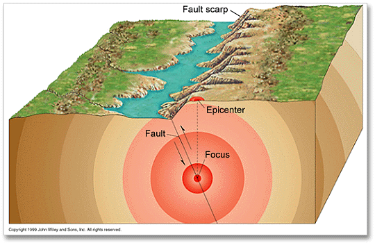
    We will look at the processes by examining two diagrams...take a look at the first:


    A perfect time to learn the vital terms within it:
    • Focus:  The point of slippage in the crust.  Where the waves start.
    • Epicenter:  The point directly above the focus on the surface of the earth.  In most cases, it is the location of the most damage.
    • Fault:  A fracture in the crust that has been caused by plate movement.  The plate movement then will cause slipping along the fault.
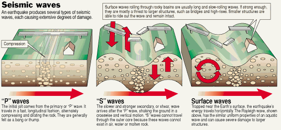
    And the second, describing how earthquakes move:

    • P-waves:  Compression waves...the first to move.  Travel very fast and not much damage.  Can travel through any earth material.  Go out from focus.
    • S-waves:  The second waves to move in...move up and down slowly and cause major damage.  Cannot move through core.   Go out from focus.
    • Surface Waves:  rolling waves that stay near the surface.  Can also cause major damage.   Go out from epicenter.

    We'll be using these terms/processes in a virtual lab...so learn them!


    Stop Here for Day 1


    General Effects of Earthquakes

    You can hypothesize some of the effects that earthquakes can have...basically this first thing that comes to your mind is damage from shaking.  That type of damage/effect is known as a primary effect of an earthquake...that is, it is a direct result of the earthquake.  Examples of primary effects are building damage, broken bridges, falling debris (could damage humans, animals, or property), landslides, floods (from collapsed dams or river banks), release of hazardous materials, and as we have seen more often lately, tsunamis.  All of these can cause major or minor damage, depending on the severity of the earthquake.

    As if that isn't bad enough, there are various secondary effects of earthquakes...effects that happen minutes, hours, or days after an earthquake as the result of a primary effect.  For example, one of the major types of secondary effect is a fire. An earthquake can lead to a busted natural gas pipe or gas tank at a gas station and explosions from broken electrical cables...not that good of a mixture.  This can cause massive fires and damages.  To make maters even worse, water pipes underneath the ground can be broken, so these fires cannot be put out.  Not having available clean water can also lead to an increase in disease spread.

    One of the major damage earthquake events in the US happened in San Francisco in 1906.  You may have learned about this in history class...the most damage in San Francisco happened as a secondary effect result of fires.  It also taught us a lot about the effects of earthquakes.  Read more about it at the links below.

    History Channel
    USGS

    Foreshocks are smaller tremors that happen prior to an earthquake and aftershocks are smaller tramors following earthquakes.  Both can cause damage...and surprise people.  Sometimes people think a foreshock is the main earthquake and a larger one comes after and following an earthquake, it is not always time to relax as an aftershock may follow.  Also, don't forget that the worst damage comes at the epicenter of an earthquake...but that does not mean it is limited to that area!

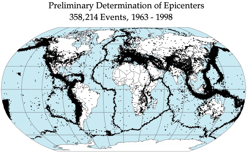
    Where Do Earthquakes Happen?

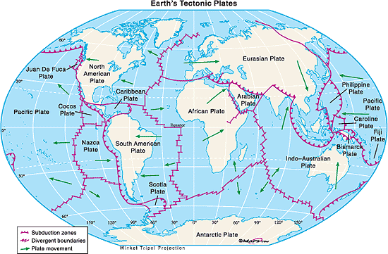
    Most of the "big" earthquakes (9/10) happen along destructive (convergent) plate boundaries, although we do know that there are frequent earthquakes at other places like the San Andreas Fault.  This is clearly shown by looking at the two figure below, the first shows the direction of plate movement, and the second shows where earthquakes happen.


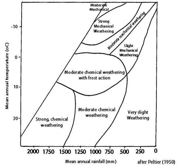
    How Do We Measure Earthquakes?

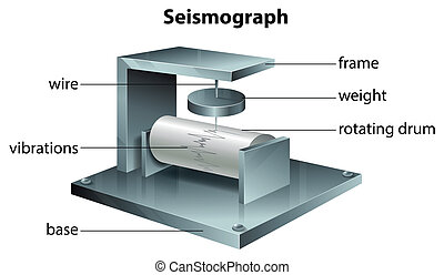
    As you will see in the virtual lab, we measure earthquake intensity using a seismograph.  The seismograph measures seismic (shaking) activity of the earth.  It is a fairly simple machine, consisting of a roll of paper that is fed continuously under a pencil or pen.  When the ground shakes, the pencil moves back and forth and shows how "intense" the earthquake is.  You can see one below.


    A very cool thing about seismographs is that they are set up all over the world, and using data from just 3 of them can let scientists know where the epicenter of an earthquake is (you will see how in the virtual lab). Why is that important???  Well, if we can determine how strong an earthquake and where it started, we may be able to warn people before tsunamis happen.  As technology gets better, we can get information to people better and have the potential to save lives.  There is no current way to predict earthquakes, so this technology is the best way to save people from earthquake damage that we have.

    Earthquakes are given an intensity measurement on something called the Richter Scale.  The Richter Scale goes from 0-10+, and each integer (1,2,etc.) is 10x as strong as the previous.  Therefore a 5 is 100x as strong as a 3.  The following table shows you how strong the different numbers on the scale are and how often they occur.


    Just a FYI...the 2004 Indian Ocean Earthquake that caused the major Tsunami was a 9.1-9.3 on the scale, the third largest ever recorded (Largest was a 9.5 in Chile in 1960).

    Earthquakes are devistating...but they do have different effects in different parts of the world.  You will learn about this in the next section.

    Thursday, September 3, 2015

    2.1.6 The Lithosphere (KQ1): The Rock Cycle

    The Lithosphere, essentially the Earth's crust, is constantly, slowly being formed and recycled from the molten rock in the mantle.  One way you have learned about this is through the divergent plate boundaries that bring the mantle to the surface and the convergent boundaries that slide it back down.  These processes are part of the rock cycle, the way that rocks change and are recycled within and on the Earth.

    There are three basic types of rock: 

    Sedimentary

    • Formed from sediments (definition 2), may be eroded fragments of other types of rocks, from dead remains of animals, or from solutions on earth that form solids via chemical reaction (these are called precipitates).
    • They can be deposited (through a process called deposition...see below) on both land and in aquatic environments.
    • Most common is limestone (Calcium Carbonate - CaCO3), formed in marine environments and is a source of many fossils.
    • Sediment accumulates of thousands of years...and can be hundreds of meters thick.
    • The pressure of this rock on top of rock is so immense that the sediments fuse together, in a process called cementation.
    • Cementation can result in sedimentary rocks such as sandstone and limestone.
    • Examples of sedimentary rocks include: conglomerate, breccia, shale, halite, gypsum, coal, and more.  Find out what these look like and more information on each by looking here.


    Limestone


    Igneous


    • Formed when magma (molten rock) cools and solidifies.
      • Quick side note...magma is within a volcano or in the mantle, lava is when that molten rock comes out of the volcano...same stuff, different location
    • Usually forms beneath the land's surface, called intrusive igneous rock
      • intrusive igneous rock cools slowly, since it is below the surface, and forms large crystals
      • examples include:  diorite, gabbro, granite and pegmatite
    • Some molten rock makes it to the surface and cools rapidly, called extrusive igneous rock
      • extrusive igneous rock will have smaller crystals due to the rapid cooling
      • examples include: andesite, basalt, obsidian, pumice, rhyolite and scoria
    • Pictures and information from both types of igneous rock can be found here.


    Granite


    Metamorphic

    • Formed when igneous or sedimentary rock is under extreme heat and pressure
      • Can happen at plate boundaries (pressure) or when in contact with magma (heat)
    • Some metamorphic rock forms in layers...this is known as foliated metamorphic rock.
      • An example is gneiss...which is formed from igneous granite.  It sure is gneiss!
    • Other metamorphic rock has no apparent ordered structure...this is known an non-foliated metamorphic rock
      • An example is marble...which is formed from sedimentary limestone.  Wow, this stuff rocks!
    • See examples of metamorphic rocks here.


    Gneiss

    Now that you know the different types of rock, you may be able to put together this whole concept of a "rock cycle."  Before we look at the "big picture," there are three primary processes that happen within it need to be familiar with:


    • Denudation - This is the process by which rocks are weathered and eroded.
      • Weathering - the breakdown of rocks in situ (they stay in place during the breakdown)
        • Chemical Weathering - chemical change of rocks reacting with air or water
        • Mechanical Weathering - breaking up of rocks...not altering chemistry
        • Biological Weathering - result of plant or animal activity (ex. roots shattering rock)
      • Erosion - the breakdown of rocks involving movement of the pieces following
        • Movement due to wind, waves, streams, rivers, or glaciers.
    • Transportation -  The processes that carry sediment or other materials away from their point of origin. Transporting media include wind, water and mantle convection currents.  Does not break down the rock itself (erosion)
    • Deposition - When materials/rocks settle out from whatever is transporting them

    FINALLY...let's take a look at the rock cycle...to do this you are going to click the link below to go to a Prezi presentation.  Prezis are really cool...all you have to do is click the arrows and follow along...it will guide you through the cycle!


    That was a pretty good, basic understanding of how it works...but it's not limited to just those directions alone...almost all of it can change to the other forms directly as shown by this graphic.