Weather and Climate
Weather and wind patterns are extremely important in terms of life on Earth...determining when major natural events will occur, major climatic regions, and whether or not it's a good beach day! Many people confuse weather with climate, so what is the difference?
Weather
– What’s happening currently…a moment in time. Weather is if it's raining, snowing, hot, or cold.
Climate
– The average weather pattern of a certain area…determines the BIOME an
area is divided into. We will discuss Biomes in the next section.
So, what causes different climates with their weather patterns? The major reason, again, is the sun, causing differences in insolation. Insolation is the
amount of solar radiation received on a surface (W/m2). Due to the tilt of the Earth, there are different
amounts of insolation for
different parts of the Earth. It is basis for the formation of the climates/biomes. There is a diagram of this below:

So, because of this, and the fact that the inside of the Earth gives off different amounts of heat to the surface, the Earth is heated unequally. When that happens, the air particles where there is more heat (energy) will rise, creating an area of low pressure below. Areas of less heat will have a higher pressure. The cooler air will rush in to fill the area left by the lower pressure. We know this movement as wind. Thus, air always flows from areas of high pressure (cool) to areas of low pressure (warm). Measuring the different pressures on Earth is a major way how meteorologists make their forecasts. We will get more into weather patterns and forecasting in 4.2.3.
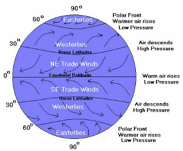
There are two types of wind systems we will discuss: Global Winds and Local Winds
Global Wind Systems
As stated before, air
generally moves from the poles to the equator, this is because air flows from
high pressure to low pressure. Globally, high
pressure forms when cold air sinks at the poles. Low
pressure forms when warm air rises at the equator. BUT, the air doesn't flow in a straight line. Why??? The answer lies in the Coriolis Effect.
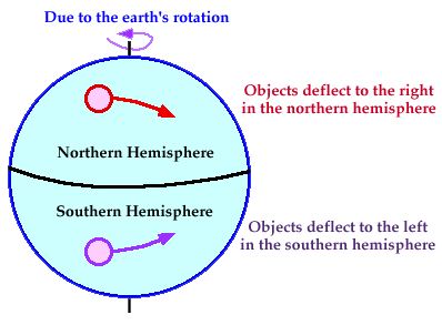
The Coriolis Effect causes
air to move in a curved path. It
is caused by the Earth spinning on its axis, where the Earth spins fastest at the equator, and slowest near the poles. As
air moves from the equator to the pole, it will travel east faster than the
land beneath it causing the air to follow a curved path.
In
the Northern Hemisphere,
the Coriolis Effect causes wind to curve to the Right facing the north pole. In the Southern Hemisphere, the Coriolis Effect causes wind to curve to the Left facing the south pole.
The global winds blow across the entire planet and generally blow at the same speed and direction. Some
are high in the atmosphere and you cannot feel them on the ground. Each
hemisphere contains 3 wind belts that divide up the planetary winds: the Trade Winds, the Westerlies, and the Easterlies.
Trade Winds
The Trade Winds blow
toward the equator, an area of low pressure called Doldrums. They are located
between 0-30º north
and south. Called
trade winds because many European sailors used these winds for trade. In
northern hemisphere, trade winds come from the NE, so they are called Northeast trade winds. In
the southern hemisphere, trade winds come from the SE, so they are called Southeast trade winds. (Winds are named for the direction they travel from.)
Westerlies
The Westerlies are between
30º
and 60º
latitude. The high
pressure at 30º
causes air to descend and blow toward the poles. This zone of high pressure at 30º are
called Horse
Latitude. In
northern hemisphere, westerlies are southwest winds. In
the southern hemisphere, westerlies are northwest winds.
Easterlies
The Easterlies are located
above 60º
latitude (between 60-90º) at both poles. The high
pressure over the poles (caused by the sinking cold dense air) causes the air
to blow away from the poles toward 60º
latitude. At the north pole, they are northeast winds since the wind comes from the northeast. (Ho Ho Ho). At
the south pole, they are southeast winds since the wind comes from the
southeast
Here is a diagram of the Global Wind Patterns:
Local Wind Systems
Local winds blow over small areas. Unlike
global winds, local winds can change speed and direction frequently. These
are the winds we feel on the ground. They
are influenced by local conditions and local temperature variations.
In coastal areas, during
the day, the land heats up faster than the water, so a breeze will blow from
the sea to the land, called a sea breeze. At
night, the land will cool off faster than the water, so the cool land air will
flow toward the warmer ocean water air, creating a land breeze,
where the wind blows from the land to the sea.

In mountainous areas, during
the day, the valley heats up, so the warm less dense air flows up the mountain,
creating a valley breeze. At
night, the mountain will cool off faster than the valley, so the cool mountain
air descends because it is more dense, creating a mountain breeze.

Rain Shadows
When air moving inland from the ocean that contains a large
amount of water vapor meets the windward side of a mountain
range (the side facing the wind), it rises and begins to experience
adiabatic cooling. Because water vapor condenses as air cools, clouds form and
precipitation falls. The presence of the mountain range causes large amounts of
precipition to fall on its windward side. The cold, dry air then travels to the other side of the mountain
range (the leeward side), where it descends and experiences higher
pressures, which cause adiabatic heating. This air is now war and dry and process arid conditions on the
leeward side forming the region called a rain shadow.

Land Relief and Ocean Currents
Ocean currents and the land both play a major role in the variety of weather and climate on Earth. Watch the following video from NASA to learn about the impacts.
No comments:
Post a Comment